

Pedernales Falls State Park covers 5,212 acres along the Pedernales River in Blanco County, about 9 miles east of Johnson City and about an hour west of Austin. It’s best known for the falls, where the river spills over wide limestone ledges, plus a swimming area downstream, about 40 miles of trails and a large campground. The park often fills on weekends, so reserve a day pass before driving out.
At a Glance
- Drive time: about 1 hr from Austin, 1.5 from San Antonio
- Entry fee: $6 ages 13 and up; 12 and under free
- Hours: gates closed 10 p.m. to 8 a.m.
- Reservations: day pass advised; often fills
- Dogs: yes, on a 6-foot leash; not at the swim area
- Swimming: downstream swim area only; not at the falls
- Camping: 69 electric sites, 21 hike-in; no cabins
- Best time: spring and fall, after a good rain
- Hunt closures: Nov. 21–24, Dec. 13–17, Jan. 18–22
- Cell signal: weak or none in most of the park
- Run by: TPWD, (830) 868-7304
On This Page
- Pedernales Falls
- Swimming, Tubing and Fishing
- Hiking Trails
- Mountain Biking and Horseback Riding
- Camping
- Bird Blind, Wildlife and Stargazing
- Best Time to Visit
- What Visitors Say
- Getting There
- Know Before You Go
- Nearby Parks
- FAQ
- Sources and Official Links
Pedernales Falls

The falls are the reason most people visit Pedernales Falls State Park. Here the Pedernales River drops about 50 feet over 3,000 feet of tilted limestone, so the falls are a wide stretch of stepped cascades and pools rather than one tall waterfall. Texas Parks and Wildlife (TPWD) dates the rock at about 300 million years old.
Swimming and wading aren’t allowed anywhere in the falls area. Visitors climb over the dry ledges instead, exploring the pools, small caves and crevices.
Getting to the Falls
The falls sit at the north end of the park road, with their own parking area and trailhead.
- TPWD lists the falls trail system at 0.3 to 1.6 miles, rated moderate; visitors report about a 10-minute walk
- The Pedernales Falls Overlook gives a view from above for anyone who doesn’t want to climb down
- The limestone has no shade and reflects heat, and wet rock gets slippery. Wear shoes with grip
- The falls area is day use only. Hikers who stay for sunset say a flashlight helps on the walk back
When the Falls Flow
Water flow depends on recent rain. Through much of October 2025 to April 2026, reviewers found the falls dry or a trickle during drought, and a few felt the visit wasn’t worth the fee. After good rains, as in September 2025 and May 2026, visitors describe strong flow over the ledges. Low water has an upside: more of the riverbed and its pools are open to explore.
Flash Floods
TPWD warns that the river can rise from a calm stream to a torrent in minutes. If the water starts rising, turns muddy or carries debris, leave the riverbed and head up the trail right away.
- July 2026: the river at Johnson City crested at 24.58 feet on July 16, well above its 19-foot major flood stage and the highest there since 2002. The park closed all trails as a precaution, and everything had reopened by August 8
- July 2025: the trails to and along the river closed briefly during the Hill Country floods, while the rest of the park stayed open
Swimming, Tubing and Fishing

Swimming is allowed at Pedernales Falls State Park, but only downstream of a marked point at the swimming area. It isn’t allowed at the falls or at Twin Falls.
- The walk down: TPWD calls the access a strenuous quarter-mile hike with steep rock stairs and no handrail. Visitors count about 100 steps and say the climb back up is a workout, so leave the cooler and canopy in the car
- The water: a sandy beach, a rocky river bottom and depths that change with the river. Visitors describe clear blue-green pools, warm water in late summer and plenty of small fish. Water shoes help
- Quieter spots: visitors walk along the bank away from the main beach for fewer people, or head to Trammell Crossing, a low-water river crossing on the Cypress Mill Loop
- Dogs: pets aren’t allowed in the water or on the land around a designated swim area under statewide park rules
- Crowds: the swim area gets busy on warm weekends
Tubing and Paddling
Tubes, canoes and kayaks can put in at the swimming area or at Trammell Crossing. TPWD bans put-ins and take-outs in the falls area, and the park has no tube or boat rentals, so bring gear.
Fishing
Common catches in the Pedernales River are catfish, bass, sunfish and carp, and TPWD says catfishing is good after a river rise. No fishing license is needed to fish inside a Texas state park.
Hiking Trails

Pedernales Falls State Park has 10 named trails, from a half-mile nature walk to an 11-mile horse trail. All trails are open to hikers and mountain bikers unless posted, and most are rated moderate.
| Trail | Miles | Difficulty |
|---|---|---|
| Pedernales Falls Trail System (the falls) | 0.3–1.6 | Moderate |
| Twin Falls Nature Trail (shady, spring-fed falls) | 0.5 | Moderate |
| Hackenburg Loop (along the river) | 1.6 | Moderate |
| Horse Trail North (hike, bike or ride) | 2.5 | Easy |
| Jones Spring Trail (rock house ruins) | 2.6 | Moderate |
| Wolf Mountain Loop (to the hike-in campsites) | 3.2 | Moderate |
| Cypress Mill Loop (river crossing) | 4.1 | Moderate |
| Madrone Trail (crosses a county road) | 4.3 | Moderate |
| Juniper Ridge Trail (technical biking) | 9.7 | Challenging |
| Horse Trail South (hike, bike or ride) | 11.4 | Moderate |
Miles as TPWD lists them; they add up to about 41 miles. TPWD notes the list may not include every trail. Use the trails map (PDF) or the interactive trails map to plan a route.
Trail Tips
Visitors repeat a few tips for the trails at Pedernales Falls.
- Wolf Mountain: TPWD lists the loop at 3.2 miles, or 5.5 miles round trip from the trailhead. Hikers describe it as mostly a wide dirt road through cedar, with few views until about mile 3
- Hackenburg Loop: one hiker lost the lower branch where it fades out at the river in August 2026. The upper route is easier to follow
- Cypress Mill Loop: the trail crosses the river at Trammell Crossing, so expect wet feet
- Twin Falls: visitors reported the Twin Falls overlooks closed for repairs in May and October 2026. TPWD’s alert page lists the trail as open, so check before going
- Water and heat: shade is thin on many trails. Bring more water than seems necessary and hike early in summer
Mountain Biking and Horseback Riding
Mountain bikers ride most trails at Pedernales Falls State Park, and riders bring horses for about 10 miles of rugged equestrian trail. Both groups share the trails with hikers, and everyone yields to horses.
- Juniper Ridge Trail: 9.7 miles of technical single-track for advanced riders. A rider in November 2025 called it mostly rock gardens and hard work
- Madrone Trail: 4.3 miles, which the same rider described as easy, twisty single-track for beginners. TPWD sells a Madrone Trailhead day pass that also covers the main park after 4 p.m.
- Bike tips: wear a helmet, and ask at headquarters which trail fits a rider’s skill
- Horse trails: TPWD calls them rocky, with steep slopes, and says riders need experience. Horses should be shod, and riders show a current Coggins test at the office before riding. There are no horse rentals
- Closed to horses: the North and South Equestrian trails closed to horse riders on October 29, 2026. Call the park before trailering in
Camping

Pedernales Falls State Park has a large campground with water and electric hookups and a hike-in primitive area. There are no cabins or screened shelters.
Campsite Types
Prices are TPWD’s per-night rates, plus the daily entry fee.
- Water and electric (69 sites, $20): 30-amp electric, water, a picnic table, a lantern post and a fire ring with grill. All sites are back-in, with most fitting rigs of 45 to 50 feet. The loop has two restrooms with showers, and a dump station is nearby. The reservation site lists 63 of these sites as bookable
- Primitive hike-in (21 sites, $10): the Wolf Ridge area, about 2 miles from the parking area by TPWD’s count. No water at the sites, no open fires, and up to 4 people per site. Water is available at the trailhead parking lot, and there’s a vault toilet in the camp area
- Youth Group Camp ($100): for nonprofit, adult-sponsored youth groups of 10 to 75 people
- Equestrian Group Camp ($40): up to 12 people and 6 horses, with horse pens and no drinking water
A primitive site is a campsite with no water, electricity or restrooms, reached on foot. Campers carry in water and fuel stoves and pack out all trash.
Reservations and Camp Rules
Book early: campers say sites are harder to get than they used to be.
- Water and electric and primitive sites open for booking 5 months ahead; group camps 12 months ahead, by phone at (512) 389-8920
- Check-in is 2 p.m. and check-out is noon
- Up to 8 people and 2 vehicles per electric site
- Campers arriving after the 10 p.m. gate closing need to call the park by 4:30 p.m. for the gate code. Primitive campers must check in at the office during office hours
- 2027 closure: the water and electric campground is set to close in 2027 for a wastewater plant project. TPWD’s alert page gives January 1 through summer 2027; a reservation-site notice from October 30, 2026 gives March 1 through early fall 2027. Check the dates before booking
- Burn bans are common in drought (the park posted them in May, August and September 2025 and February 2026). Bring a gas or electric stove as a backup
Campers describe roomy sites with brush between them and a covered picnic table at many sites. Some RV sites are badly unlevel, so bring levelers, and check the site photos for shade before booking.
Bird Blind, Wildlife and Stargazing
TPWD counts more than 150 bird species at Pedernales Falls State Park, and its bird blind is one of the most praised stops in reviews. The endangered golden-cheeked warbler nests here, arriving in mid-March.
- Bird blind: open-air, with a 35-foot glass viewing wall and feeders kept full all year. A 100-foot paved path makes it wheelchair accessible, and it’s always open. A butterfly garden sits next to it
- What visitors see: painted buntings in summer, foxes near the blind, deer on the trails and turtles in the river pools. A sign at the blind reminds visitors to check for snakes before sitting
- Wildlife TPWD lists: white-tailed deer, coyotes, armadillos, raccoons and wild turkeys
- Stargazing: the park’s Star Theater opens for astronomy programs, and the events calendar lists star parties and night hikes. It isn’t an International Dark Sky Park, but visitors call the sky among the best within an hour of Austin. After-hours stargazing adds a $2 activity fee per person
- Ranger programs: history hikes, hands-on programs and a Junior Ranger program, listed on the park events page
Best Time to Visit
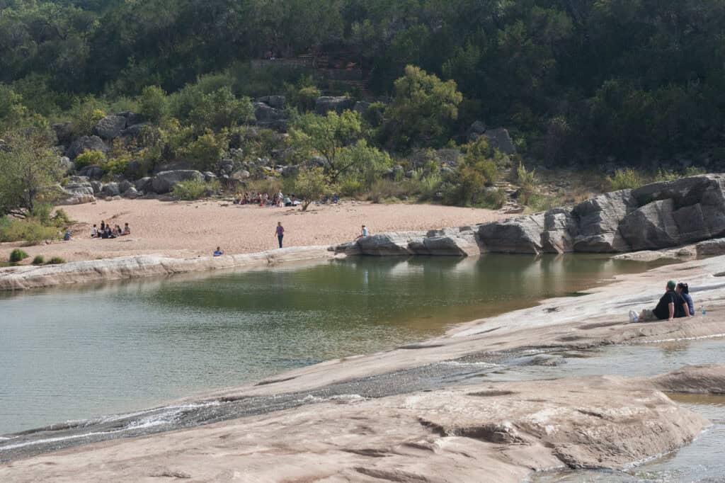
Spring and fall are the best seasons at Pedernales Falls State Park, with mild hiking weather and the best odds of water over the falls after rain. Summer is hot on the open rock, and the park closes on set dates for public hunts from November to January.
- Spring (March to May): visitors report wildflowers in April and early May, and golden-cheeked warblers arrive in mid-March. Spring break weekends sell out
- Summer (June to August): July averages a high of 94°F, and the rocks have no shade. Hike early, then cool off at the swim area. Weekdays are quieter
- Fall (September to November): cooler hiking and some fall color along the river in November. Check the hunt dates before booking
- Winter (December to February): January lows average 32°F. Trails are quiet on weekdays, but day passes still sold out on some weekends in December 2025 and January 2026
For the falls: May, August and September are the wettest months. The falls flow best in the days after a good rain, once the river is back to a safe level.
What Visitors Say
Pedernales Falls State Park averages 4.8 stars across about 660 Google reviews from November 2024 to October 2026, and 4.8 across more than 5,000 reviews overall. Most visitors love the falls and the clean facilities, and the complaints are consistent.
- Clean restrooms: the most repeated praise, with new or renovated restrooms and showers noted in 2025 and 2026. Headquarters has only one restroom, so use the one at the falls
- Low water: the most common complaint. In drought the falls can be dry or a trickle, and most low ratings in the window came from those visits
- Sell-outs: reviewers say to buy the day pass online before leaving home. One family with a reservation found the gate sold out for walk-ups in December 2025
- The steps: the stairs down to the swim area and the rocky scrambles are hard for limited mobility, small children and older dogs
- Heat: summer temperatures topped 100°F on some hikes, and one visitor needed EMTs for heat illness in August 2025
- Staff: rangers and gate staff get frequent praise, and visitors enjoyed the ranger history walks
- Cell service: weak or none in much of the park. Wi-Fi works at headquarters
Getting There
Pedernales Falls State Park is at 2585 Park Road 6026, about 9 miles east of Johnson City on FM 2766. From Austin, TPWD’s route takes US 290 west for 32 miles, then FM 3232 north for 6 miles to FM 2766 and the park entrance.
Drive times to park headquarters:
- Austin: about 1 hour
- San Antonio: about 1 hour 35 minutes
- Houston: about 3 hours 50 minutes
- Dallas: about 4 hours 20 minutes
A few things to know before driving out:
- Maps apps: TPWD tells iPhone Maps users to enter the address as Cypress Mill, TX 78636. One couple reported driving 30 extra miles on a bad route
- Day pass first: buy it before leaving home, since cell signal at the park is weak
- Horse trailers: the Equestrian Group Camp entrance is on Pedernales Falls Road, about half a mile east of the main entrance
- Floods: heavy rain closes the river trails fast. Check the park alerts the day of the trip
Know Before You Go
Pedernales Falls State Park is busy, hot in summer and quick to flood. These fees, rules and tips matter most.
- Fees and passes: $6 a day for ages 13 and older; children 12 and under get in free. The Texas State Parks Pass ($70 a year) covers entry for the holder and guests
- Booking: day passes open 1 month ahead in entry time slots (8 to 10 a.m., 10 a.m. to noon, 1 to 4 p.m. and 4 to 10 p.m.); once inside, visitors can stay the rest of the day. Passes are sold at the gate only if any are left. Campsites open 5 months ahead
- Hours: gates are closed from 10 p.m. to 8 a.m., and day-use visitors leave by 10 p.m. Headquarters is open 8 a.m. to 4:30 p.m.
- Dogs: allowed on a leash no longer than 6 feet; not in the swim area or park buildings. Carry proof of rabies vaccination
- Alcohol: public drinking or displaying alcohol is against park rules
- Fires: burn bans are common in drought. No open fires at the primitive sites at any time
- Hunts: the whole park closes for public hunts from 10 p.m. the night before to 2 p.m. on the last day: Nov. 21–24 and Dec. 13–17, 2026, and Jan. 18–22, 2027
- Private land: private property borders the park, including the far side of the river. Stay inside the park boundary
- What to bring: shoes with grip for the rocks, water shoes for the river, sun protection, an offline map and a day pass reserved ahead
Check conditions first: the park closes for floods, hunts and capacity, and the river changes fast after storms. Check the Pedernales Falls park alerts page or call (830) 868-7304 before driving out.
Nearby Parks
Five other TrekTexas guides are within about 90 minutes of Pedernales Falls State Park.
- Hamilton Pool: about 21 miles east, a collapsed limestone grotto with a waterfall
- Reimers Ranch Park: about 23 miles east on the same river, known for rock climbing and biking
- Blue Hole: about 34 miles southeast in Wimberley, a cypress-shaded swimming hole
- Krause Springs: about 40 miles northeast in Spicewood, a private swimming hole with camping
- Enchanted Rock: about 60 miles northwest, known for its granite dome hike
- More parks within reach of Austin: Parks Near Austin
FAQ
Are there cabins at Pedernales Falls State Park?
No. The park has water and electric campsites, hike-in primitive sites and two group camps, but no cabins or screened shelters.
Is Pedernales Falls worth visiting when the water is low?
For many visitors, yes: low water opens more of the riverbed, pools and ledges to explore. Anyone coming mainly to see water pouring over the falls should wait until a few days after a good rain.
Is there a map of Pedernales Falls State Park?
Yes. TPWD publishes a park map (PDF), a trails map (PDF) and an interactive trails map.
Is Pedernales Falls a national park?
No. It’s a Texas state park run by Texas Parks and Wildlife, on land that was once the Circle Bar Ranch.
Sources and Official Links
Facts in this guide were last checked in October 2026 against these sources.
- Pedernales Falls State Park (TPWD)
- Entrance fees and campsites (TPWD)
- Trail list, park map (PDF) and trails map (PDF) (TPWD)
- Park alerts (TPWD)
- Group facilities and accessibility (TPWD)
- Pet rules (TPWD)
- Texas State Parks reservations
- Pedernales River at Johnson City gauge (National Weather Service)
Featured photo: Ashton Brown
Get More Texas Outdoor Adventure Tips
Subscribe to get more places to explore in the great outdoors of Texas. We’ll never share your email. Unsubscribe any time.




Comments are closed.